Giambattista Nolli


지암바티스타 놀리(또는 지오반니 바티스타)(1701.4.9 – 1756.7.3)는 이탈리아의 건축가이자 측량사였다. 그는 1736년에 측량을 시작하여 1748년에 판각한 평면도법 지도인 ‘피안타 그란데 디 로마’로 가장 잘 알려졌으며, 이 지도는 현재 일반적으로 ‘놀리맵’으로 알려져 있다. 이 지도는 가로 176cm(69인치), 세로 208cm(82인치) 크기의 동판화 12장으로 구성되어 있다. 이 지도는 로마의 14개 전통 ‘리오니’ 또는 구역의 경계를 설정하는 데 도움을 주기 위해 교황 베네딕토 14세의 의뢰로 제작 및 출판되었다. 그것은 교황청의 건축적 업적이 만개했던 시기에, 당시까지 제작된 로마에 대한 묘사 중 단연코 가장 정확한 것이었다.
Giambattista Nolli (or Giovanni Battista) (April 9, 1701 – July 3, 1756), was an Italian architect and surveyor. He is best known for his ichnographic plan of Rome, the Pianta Grande di Roma which he began surveying in 1736 and engraved in 1748, and now universally known as the Nolli Map. The map is composed of 12 copper plate engravings that together measure 176 centimetres (69 in) by 208 centimetres (82 in). It was produced and published in response to the commission of Pope Benedict XIV to survey Rome in order to help create demarcations for the 14 traditional rioni or districts. It was by far the most accurate description of Rome produced to date at a time when the architectural achievement of the Papacy was in full flower.
전기
Biography
카스틸리오네딘텔비(코모)에서 1701년에 태어난 그는 귀족인 알바니와 코르시니 가문의 후원으로 로마로 이주했다.
Born in 1701 in Castiglione d’Intelvi (Como), he moved to Rome thanks to the patronage of members of the patrician Albani and Corsini families.
그는 아벤티네 언덕의 산탈레시오 성당(1743)과 트라스테베레의 산타도로테아 성당에서 건축가로 일했다.
As an architect, he worked on the churches of Sant’Alessio on the Aventine Hill (1743) and Santa Dorotea in Trastevere (1751–1756).
놀리맵
Nolli Map
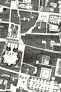
놀리맵은 1551년 부팔리니의 지도를 반영하고 있어 비교가 쉽지만, 놀리는 여러 가지 중요한 혁신을 이루어냈다. 첫째로, 놀리는도시의 방향을 (당시 관례였던) 동쪽 대신 자북으로 재배치했는데, 이는 도시의 지형을 파악하기 위해 나침반에 의존하는 놀리의 특성을 반영한 것이다. 둘째로, 놀리는 블록과 건물을 어둡게 음영 처리한 포셰 기법을 사용하여 지어진 공간을 표현하는 부팔리니의 방식을 따르면서도, 성 베드로 광장의 주랑이나 판테온 같은 폐쇄된 공공 공간을 열린 시민 공간으로 묘사했다. 마지막으로, 이 지도는 스페인 계단의 비대칭성을 지적할 정도로 정확도가 크게 향상되었다. 이 지도는 1970년대까지 로마 시를 위한 정부 계획에 사용되었으며, 그 이후까지 모든 로마 지도 제작 및 계획의 기본 지도로 사용되었다.
The Nolli map reflects Bufalini’s map of 1551, with which Nolli readily invited comparison, however Nolli made a number of important innovations. Firstly, Nolli reorients the city from east (which was conventional at the time) to magnetic north, reflecting Nolli’s reliance on the compass to get a bearing on the city’s topography. Secondly, though he follows Bufalini in using a figure-ground representation of built space with blocks and buildings shaded in a dark poché, Nolli represents enclosed public spaces such as the colonnades in St. Peter’s Square and the Pantheon as open civic spaces. Finally, the map was a significant improvement in accuracy, even noting the asymmetry of the Spanish Steps. The map was used in government planning for the city of Rome until the 1970s; it was used as a base map for all Roman mapping and planning up to that date.
이 지도는 스테파노 포찌의 ‘베두타1‘로 테를 두르고 있다. 원본 지도가 완성된 같은 해에 놀리와 지오반니 바티스타 피라네시가 협업한 축소판이 출판되었다. 피라네시는 이 작품이 인쇄되는 데 중요한 역할을 했으며, 주세페 바시도 기여했다.
The map is framed with a vedute by Stefano Pozzi. A scaled-down edition, a collaboration between Nolli and Giovanni Battista Piranesi, was published in the same year the original map was finished. Piranesi was instrumental in getting the work printed; Giuseppe Vasi also contributed.
- 출처 : 「Giambattista Nolli」, Wikipedia(en), 2024.11.16.
- 원래의 뜻은 ‘보여진 것,경치’의 뜻이나 특히 18세기 베네치아파 화가가 베네치아의 경관을 원근법적 구성 아래 즉물적으로 나타낸 진경화적(眞景畫的) 작품을 말한다. ㅡ 미술대사전(용어편) ↩︎